Thứ Sáu, 26 tháng 5, 2017

Palace of Versailles

Treat yourself to a taste of opulence: the Palace and its gardens are one of many historical buildings that you can wander inside via Street View.

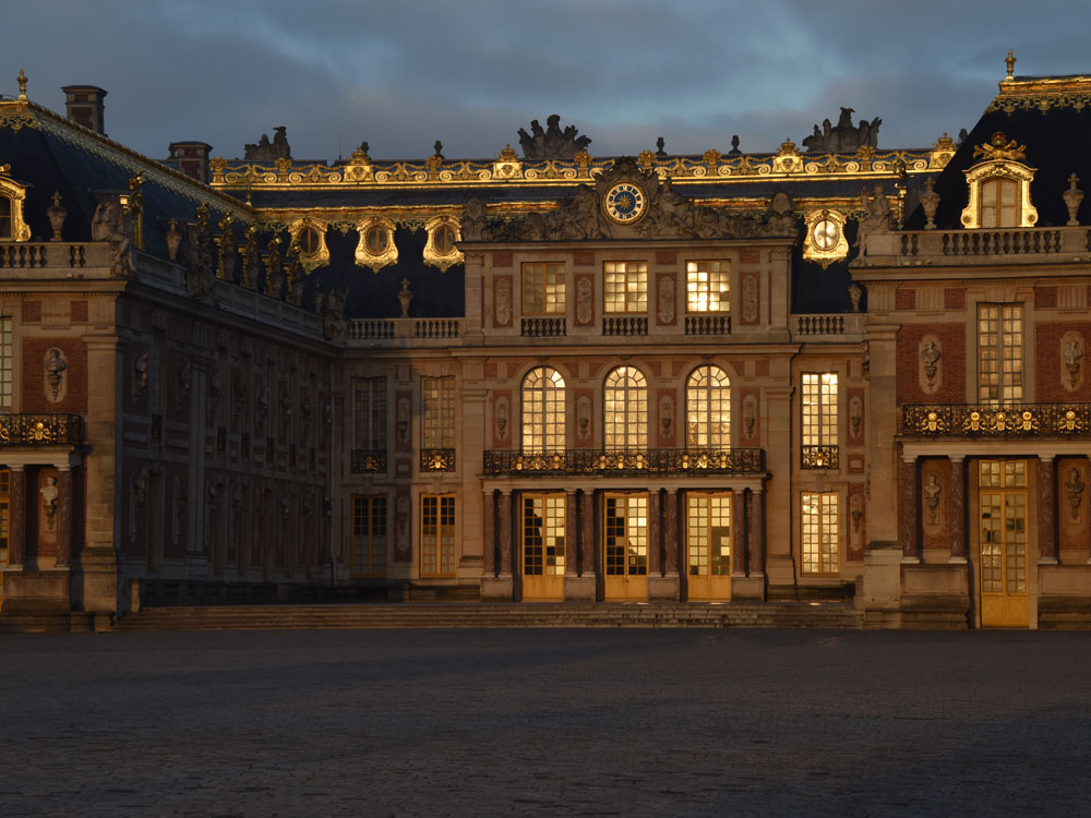
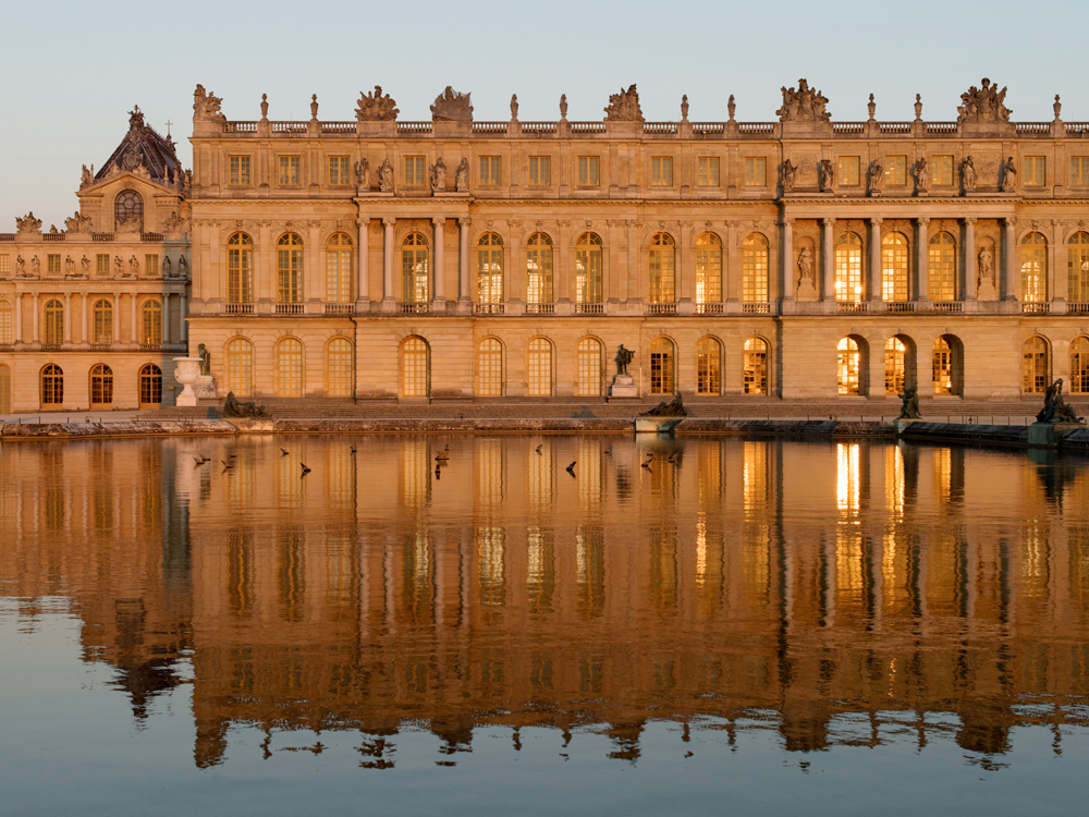
Listed for the past 30 years as a UNESCO World Heritage Site, the Palace of Versailles constitutes one of the finest achievements of French art of the 17th century. The former hunting lodge of Louis XIII was transformed and extended by his son Louis XIV who installed here the Court and the government of France in 1682. Up until the French Revolution, a line of kings succeeded each other, each taking his turn to embellish the Palace.The Hall of Mirrors, the King's Grand Apartments, the gardens… The Palace of Versailles is one of the most visited cultural sites in the world today.

Today the Palace contains 2,300 rooms spread over 63,154 m2.


In 1789, the French Revolution forced Louis XVI to leave Versailles for Paris. The Palace would never again be a royal residence and a new role was assigned to it in the 19th century, when it became the Museum of the History of France in 1837 by order of King Louis-Philippe, who came to the throne in 1830. The rooms of the Palace were then devoted to housing new collections of paintings and sculptures representing great figures and important events that had marked the History of France. These collections continued to be expanded until the early 20th century at which time, under the influence of its most eminent curator, Pierre de Nolhac, the Palace rediscovered its historical role when the whole central part was restored to the appearance it had had as a royal residence during the Ancien Régime.

The Palace of Versailles never played the protective role of a medieval stronghold. Beginning in the Renaissance period, the term "chateau" was used to refer to the rural location of a luxurious residence, as opposed to an urban palace. It was thus common to speak of the Louvre "Palais” in the heart of Paris, and the "Château” of Versailles out in the country. Versailles was only a village at the time. It was destroyed in 1673 to make way for the new town Louis XIV wished to create. Currently the centrepiece of Versailles urban planning, the Palace now seems a far cry from the countryside residence it once was. Nevertheless, the garden end on the west side of the Estate of Versailles is still adjoined by woods and agriculture.


Source: en.chateauversailles.fr

Thứ Sáu, 14 tháng 4, 2017

Go back in time with Street View


If you’ve ever dreamt of being a time traveler like Doc Brown, now’s your chance. Starting today, you can travel to the past to see how a place has changed over the years by exploring Street View imagery in Google Maps for desktop. We've gathered historical imagery from past Street View collections dating back to 2007 to create this digital time capsule of the world.
Now with Street View, you can see a landmark's growth from the ground up, like the Freedom Tower in New York City or the 2014 World Cup Stadium in Fortaleza, Brazil. This new feature can also serve as a digital timeline of recent history, like the reconstruction after the devastating 2011 earthquake and tsunami in Onagawa, Japan. You can even experience different seasons and see what it would be like to cruise Italian roadways in both summer and winter.


Forget going 88 mph in a DeLorean—you can stay where you are and use Google Maps to virtually explore the world as it is—and as it was. Happy (time) traveling!

Thứ Năm, 23 tháng 3, 2017

Animating New York's Building Boom With Google Street View

Google Street View creates what feels like a seamless (if pixelated) tour of city streets, and it's one that you could wander through all day if you had the patience to keep clicking. Virtually walk down any road, though, you may notice that sometimes the weather changes, or the seasons do.

Street View knits together a simultaneous patchwork of images taken at different times, and that means the site offers a quirky visual history of evolving neighborhoods – if, that is, you know exactly where to look.

Justin Blinder, an artist, programmer, and designer based in Brooklyn, stumbled across several of these wrinkles in Google Street View time while searching for ways to visualize how the city had changed under Michael Bloomberg, for a collaborative art project called Envision New York 2017.

"The two prominent elements for me of the Bloomberg Administration seemed to be one, the opening of city data," Blinder says, "and the other was this generally perceived accelerated gentrification."

He wanted to use the one to narrate the other. So he pulled up the city's recently released PLUTO dataset of property parcels, searched for those developments that were only a few years old, then went looking for their addresses in Street View.

"I immediately started seeing that most of the locations were actually vacant lots," Blinder says. The Google car hadn't driven by since the new luxury condos or office buildings or mid-rise rentals had gone up.

Because of how Google documents streets, though, one intersection may be viewed from multiple angles captured at different moments in time. Maybe a Google car passed down India Street in Brooklyn two years ago. Then another car came down McGuinness Boulevard earlier this winter. Stand at the intersection of those two roads, and the scenes change dramatically.

"You’ll realize that they were taken at two completely different times," Blinder says, "and sometimes the delta between those times is so great that it actually spans the development of an entire building."

As it turns out, a GIF may be the perfect medium to capture how it feels when new buildings seemingly pop up in your neighborhood overnight (Blinder, though, leaves it to the viewer to decide if this is gentrification in motion).

Blinder went back to the PLUTO dataset specifically looking for other recent corner-lot developments that might be viewed this same way


Blinder has come to look at Google Street View images of city streets as a kind of database of information. Google Street View itself isn't all that old (and older images as Google updates them aren't publicly archived anywhere online). But his project suggests that the mapping giant's Street View cars may be inadvertently documenting all kinds of processes of urban change.
Source: citylab.com

Thứ Năm, 16 tháng 3, 2017

Google Street View Offers Cobb Businesses Virtual Tour Technology

The virtual tour technology will be showcased at area firms on March 24 and 25.

COBB COUNTY, GA -- Cobb County businesses will be able to show 360-degree panoramic views of their interiors online in a new partnership between the county's Chamber of Commerce and Google Street View, Patch has learned.
The virtual tour technology will be showcased at area businesses on March 24 and 25.
Having virtual tour-capability attached to an online business has an added benefit: It helps the firm's Google Maps and Search rankings.
To get the virtual tour footage, Google Street View sends a professional team out to take high-resolution panoramic images. The team then publishes the photos directly into the Google business listing. They also provide a copy of the images to the business to post on social media or their respective websites.
The chamber met with the Google Street View team last month, enlisting several area entities -- including Life University, Capital Cadillac, Bells Ferry Learning Center, West Cobb Church and others -- into a dry run.
       Image via Google Street View
Source: patch.com

Thứ Năm, 9 tháng 3, 2017

Google Street View Alternatives

Other Options For Nosing Around
Google has cornered the market in street-level photographic mapping, but are there other alternatives?
Google Street View was first introduced to the world all the way back in 2007, with a limited number of American cities, but with a Sergey Brin-driven dream that one day they’d map the entire world at street level , you can now go on virtual tours of exciting far-flung places that you may otherwise never have the chance to see.
The 360° view of the world is now built in to Google Maps and Google Earth, both on desktop computers and the Android smartphone platform, and used daily by millions of people to pin-point locations they’re planning on visiting, or to simply have a closer look at famous places of interest.Most of the UK was mapped by the end of 2009, though the question is that, if you actively choose not to use Google’s services, are there any other sable options available?            
Microsoft Bing Maps
Launched in December 2009, Microsoft’s alternative to Street View - named Streetside - was tied in to the 2010 Winter Olympics and started with imagery of British Columbia, before slowely making its way across America, and eventually Europe in 2012.
Streetside works in much the same way in most major cities throughout the UK, but with more limited coverage than Google’s blanket offering, there’s still no street level imagery in smaller towns and the countryside.
Navigating the street-level imagery is straightforward and quite similar to Google’s system, and whilst some images suffer from less visual artefacting than Street View, images are generally of a slightly lower quality, especially if you zoom in.

Nokia HERE Maps

Based on technology originally developed by Chicago-based mapping company NAVTEQ, Nokia’s mapping service has gone through a number of evolutions on its way to becoming what is now known as HERE maps.
Back in 2011, Earthmine would have featured on this list alongside Bing and HERE, where it not for Nokia buying them out in 2012 and amalgamating their mapping technology. HERE’s street-level imagery is now simply referred to as street-level mapping, and uses a combination of image sources, which is sometimes identical to Microsoft’s Bing maps, and other times completely different.
Because of the variation in mapping sources, image quality does vary between areas, and it suffers the same coverage black-spots as Microsoft’s Streestside imagery, leaving it again some way behind Google’s Street View service.

OpenStreetView.org

The final alternative we were able to track down is a little different, and comes in the form of sporadic user-captured photographs that are tagged in on a map with their location. It’s a far cry from Street View, but gives some great views from a whole host of locations around the UK, and the world.
As you’d expect with any service that relies on its users to submit content, photographs are few and far between, and really only London has a useful amount of photos in its library.
You can easily tell where more active users are located, as there’s a rash of photographs concentrated in certain areas, but really OpenStreetView is more of a bit of fun than any worthwhile competitor to Google Street View. In many ways its closer to (the far more populated) ‘Panoramio’ - which is built in to Google Maps - than Street View itself.
If you’ve got a Windows phone from Nokia or one of the other few proponents of Microsoft’s mobile OS, then HERE Maps and Bing Maps are worthy alternatives to Google Street View, but only really if you live in one of the larger cities throughout the UK. For everyone else, nothing comes close to the almost blanket coverage that Google’s service provides, and we can’t see that changing any time soon.
Source: http://www.lifehacker.co.uk/

Thứ Ba, 28 tháng 2, 2017

Street View: Beautiful Art

STREET VIEW GLITCHES

Italian artist Emilio Vavarella has turned Google Street View into something beautiful.
Vavarella’s project “Report A Problem” consists of 100 screenshots of Google Street View malfunctions.